


GIS IMPROVEMENTS
Williston, North DakotaAbout the Project
The City of Williston worked to develop, implement, and establish a long-term preventative and condition-based maintenance program for equipment and infrastructure assets within the Public Works, Wastewater, Water, and Engineering Departments.The City’s goal was to implement a Computerized Maintenance Management System (CMMS) to provide a GIS-centric work order management and asset inventory tracking system allowing access to data and reporting for several types of analysis.
Project Details
Date: 2016
Client: City of Williston
Key Project Elements
- User Input Workshops
- GIS Implementation Plan
- Collection of Utility Data
Plan Development and Data Collection
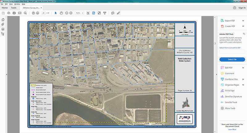
The AE2S GIS team led workshops with several City departments, developed an Implementation Plan, and collected utility data in the field to fill in data gaps.Through this partnership, they transitioned from hosting their utility data on CAD layers to a GIS-friendly geodatabase. Data from the geodatabase is published to ArcGIS Online as feature services, which are referenced in web/mobile GIS applications and the asset management software.
Gathering User Input
AE2S’ GIS team led workshops with several City Departments to discuss, review, and gain input on expanding the role of GIS to support departments city-wide and transitioning the GIS to be compatible with the City’s CMMS. Utilizing input from the intended users of the GIS was crucial to building a GIS meaningful to the end user and able to be incorporated with CMMS.Enhancing Data Analysis and Recommendations
The GIS Implementation Plan outlined the existing system and prioritized action items. This included creating objectives, analyzing existing data, and providing recommendations. From the Implementation Plan, the team identified GIS layers with data gaps. Fields were standardized for attributes.To spark conversation and provide a better perspective of the plan, diagrams showing the interaction of software, hardware, applications, and users, as well as anticipated workflow between the database datasets, department responsibilities, and applications used were created.
These diagrams display the interaction of software, hardware, applications, and users. The diagrams also showed anticipated workflow between the database datasets, department responsibilities, and applications used.
Implementation
Based on strategies laid out in the Implementation Plan, the team surveyed water, sanitary sewer, and storm sewer system features, organized geodatabase features, updated schema datasets, and realigned system pipelines to corrected locations based off surveyed assets.In the final steps, the team provided the geodatabase to be referenced by GIS applications (desktop and web), and set up improved workflows by working with the City of Williston GIS staff to develop tools that automate repetitive and time consuming tasks.
Tagged Municipalities and Utilities