


GIS FOR FARGO-MOORHEAD METROPOLITAN AREA FLOOD DIVERSION PROJECT
Cass County, North DakotaAbout the Project
The Diversion Authority, made of up of stakeholder entities in the Fargo and Moorhead area, is working on permanent flood protection for the community.The FM Area Diversion Project will protect the community from a catastrophic flood event and prevent an estimated $10+ billion in flood related damages. The project includes a diversion channel, southern embankment, and upstream mitigation area.
Project Details
Date: 2013 – Present
Client: Cass County Joint Water Resources District
Key Project Elements
- Phased Implementation
- GIS
- Interactive Online Maps
- Public Communication
Partnership for a Groundbreaking Project
AE2S has worked with the Diversion Authority for almost a decade in various programmatic capacities, including offering communication services, land management services, survey, and GIS support.The project is expected to be constructed through a Public-Private Partnership (P3), in addition to work by the U.S. Army Corps of Engineers. The Diversion is actually the first P3 project with the Corps involved. The estimated cost of the project released in December of 2018 was $2.75 billion.
The Fargo-Moorhead Diversion relies on GIS to move efficiently through the planning phases of the project. As one of the first tasks of the planning phase, maps of the diversion area coded by jurisdiction were created. This enabled the team to establish contact with various agencies and organizations along the proposed routes being evaluated.
GIS Streamlines Planning Efforts
GIS continues to play an important role in the planning and design phases of the project by:
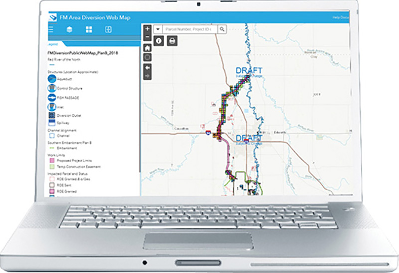
- Providing the public with online maps showing affected properties and project alignment
- Publishing online maps for use by the client and its contractors
- Maintaining maps showing affected properties and proposed easements/acquisitions
- Displaying flood plain mapping and existing conditions
- Using GIS to assist utility owners along the proposed project route
- Display and analyze transportation improvements and planning
- Maintain workflow programs to track land acquisition for the Diversion Authority and long-term easement acquisition for USACE
Leveraging the Power of Spatial Information for Effective Project Management
Large paper posters of the maps generated from the GIS prove to be extremely helpful at public information meetings. The maps and tables generated by GIS are also used in publications regarding the project. GIS is also used to calculate costs by applying land costs to acreages identified for various needs, such as easement or buy-out.AE2S uses GIS as a central storage interface for spatial information, such as preliminary designs by other firms, scanned documents, soils information, and ownership contact data. GIS has proven to be invaluable thus far on this immense project.
The GIS has become a tool for management and maintenance, both now and long after construction of the project is complete.