A customized geographic information system (GIS) tool received an Engineering Excellence Award from the American Council of Engineering Companies (ACEC) of North Dakota in the Surveying and Mapping Technology category.
The GIS solution was developed by AE2S for the McKenzie County Water Resource District (MCWRD) System IV Part IV Project, a 150-mile potable water distribution pipeline in northwestern North Dakota. For 93 residents in northwest North Dakota, receiving water directly through pipelines was a distant dream 20 years ago.
MCWRD faced significant challenges in expanding the drinking water distribution system across 50 miles of protected Little Missouri National Grassland. Navigating strict environmental regulations and providing seamless collaboration among stakeholders – including the U.S. Forest Service – were critical to keeping this large-scale, multi-user project on track and within budget. The team was presented with a myriad of protected species whose habitats could not be disturbed during specific periods during the year, and it was a challenge to keep the different schedules straight. There was an additional issue with the limitations of traditional project management tools which often created delays. Updates to pipeline progress, construction photos, and environmental alerts required lengthy manual processes.
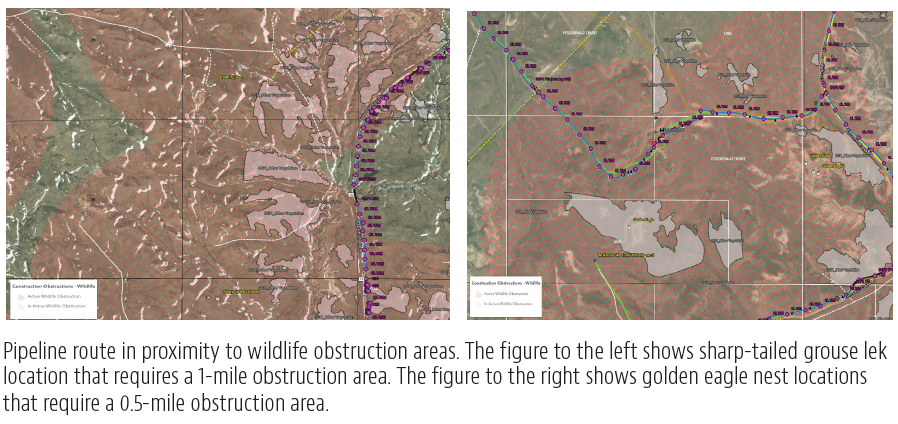
The customized GIS tool for this pipeline project was designed for National Environmental Policy Act (NEPA) requirements, safeguarding critical areas while allowing efficient work during the State’s limited construction season. “AE2S implemented customized ArcGIS web maps to provide real-time updates for both field and office teams. The GIS tool streamlined project management by instantly sharing changes and critical environmental data, such as nesting habitats, with McKenzie County Water Resource District, U.S. Forest Service, and contractors,” explains Lucas Rengstorf, AE2S Lead GIS Specialist. “What once took days to update manually could be shared in minutes, enhancing collaboration and expediting decision-making.”
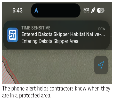
The GIS tool provides phone alerts to users who enter an area of restricted access in a sensitive geography. The notification tells the recipient when it is safe to enter that area and what extra measures are needed during construction. By continuously updating the GIS system, AE2S enabled efficient compliance with environmental regulations and reduced project delays, which led to maintaining the project’s schedule and budget.
As a significant component of the Western Area Water Supply Project, this pipeline initiative is transforming water access for rural communities in northwest North Dakota, helping to safely and more effectively meet the region’s domestic, commercial, and agricultural water needs.